View All


 View All


 View All


 View All


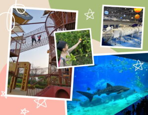
The UNESCO Global Geopark is one of the most incredibly beautiful and pristine places in Hong Kong. Here’s everything you need to know for planning a family day trip.
If you haven’t heard of the Hong Kong UNESCO Global Geopark before, now is the time to add it to your must-visit list. A geopark is an area designated by the United Nations Educational, Scientific and Cultural Organisation (UNESCO) in an effort to preserve, highlight and protect rare sites of geological importance.
Hong Kong’s Geopark covers a 50 km² area and has highly unique rock features that will both wow your family and get them excited about the phenomenal outdoors that Hong Kong has to offer. Since the geopark is such a large area, we’ve compiled some family-friendly details to get you started on planning your day trip. The Hong Kong Geopark also gives some great recommendations for tours in each area on its website.
Read More: Wild Animals In Hong Kong – Where To See Wildlife In And Around The City
The Hong Kong UNESCO Global Geopark
Hong Kong’s UNESCO Global Geopark covers two sections of Hong Kong: Sai Kung and a part of the New Territories near the Plover Cove Reservoir and Country Park. Some islands and areas are accessible by land while others are only accessible by boat but the majority of them are easily available to book for local or private tours.
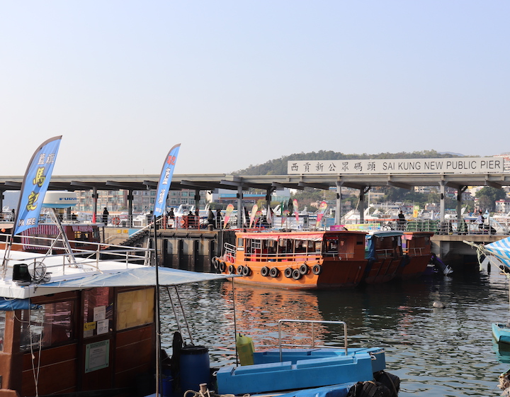
 Sai Kung
The Sai Kung formations are likely the most accessible for families as it is the tourist hub of the UNESCO Global Geopark. It is also the best location if you have young children as you can still see a piece of the geopark without being too far away from amenities.
At Sai Kung pier, especially on weekends, the main strip is inundated with tour boat companies that will take you to the outlying islands (including those not considered part of the geopark) near Sai Kung. Some are view-only tours while others allow you to visit and explore some of these breathtaking places. Most of the tours have signs advertising where they are going in English with very reasonable prices.
We’ve provided you with all the details you need to narrow down your island choices and you can always ask the providers what islands they go to once you have one in mind. Additionally, if you would prefer something custom, the companies should be able to work with you to get you the tour that you’re looking for.
Read More: Sai Kung Neighbourhood Guide For Families In Hong Kong
Volcano Discovery Centre
At the Sai Kung Water Park you can find the Volcano Discovery Centre. This hands-on centre is great for showing kids the history behind the rocks in the UNESCO Global Geopark and how they are formed. The centre even offers free guided tours.
Exhibition Area Hours: 9:30am to 4:30pm every day
Sassy Mama Tip: The Volcano Discovery Centre is quite tiny and can get very busy at the weekends with the occasional line-up to get in. The best time to visit is in the morning.
![]() Volcano Discovery Centre, Sai Kung Waterfront Park, Sai Kung, New Territories, Hong Kong, 2394 1538, www.volcanodiscoverycentre.hk.
Volcano Discovery Centre, Sai Kung Waterfront Park, Sai Kung, New Territories, Hong Kong, 2394 1538, www.volcanodiscoverycentre.hk.
Geopark Visitor Centre (Lions Nature Education Centre)
The Geopark Visitor Centre (LIONS Nature Education Centre) is also located in the Sai Kung and is a quick bus or cab ride away from the pier. It has a much larger and amazing exhibition hall that is perfect for kids. To get to the centre from Sai Kung Pier get on green minibus 1A and get off at Pak Kong and walk about 5 minutes to the centre.
Exhibition Hall Hours: Monday, Wednesday to Sunday & Public holidays: 9:30 am to 4:30 pm
![]() Lions Nature Education Centre, Tsiu Hang, Sai Kung, 2792 2234, www.afcd.gov.hk
Lions Nature Education Centre, Tsiu Hang, Sai Kung, 2792 2234, www.afcd.gov.hk
Read More: Kids’ Activities – Things To Do With Kids In Hong Kong This Month
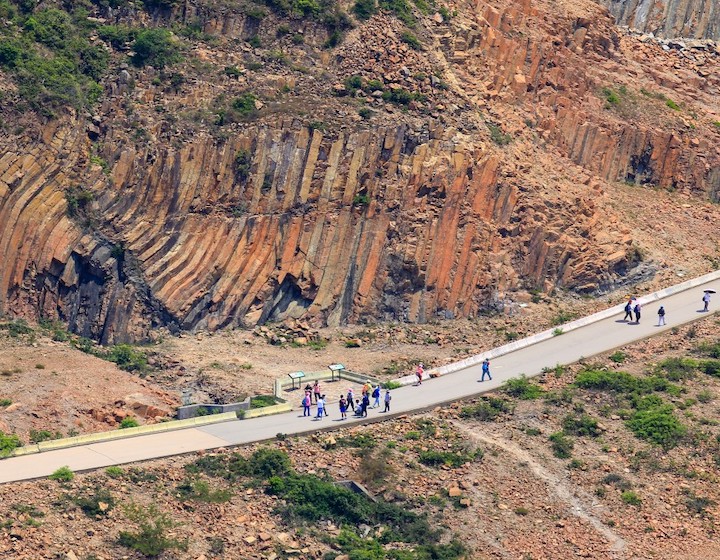
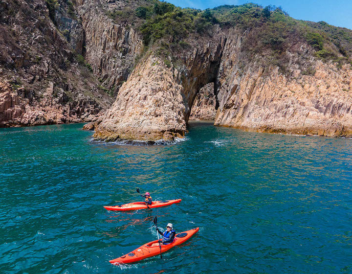
 High Island
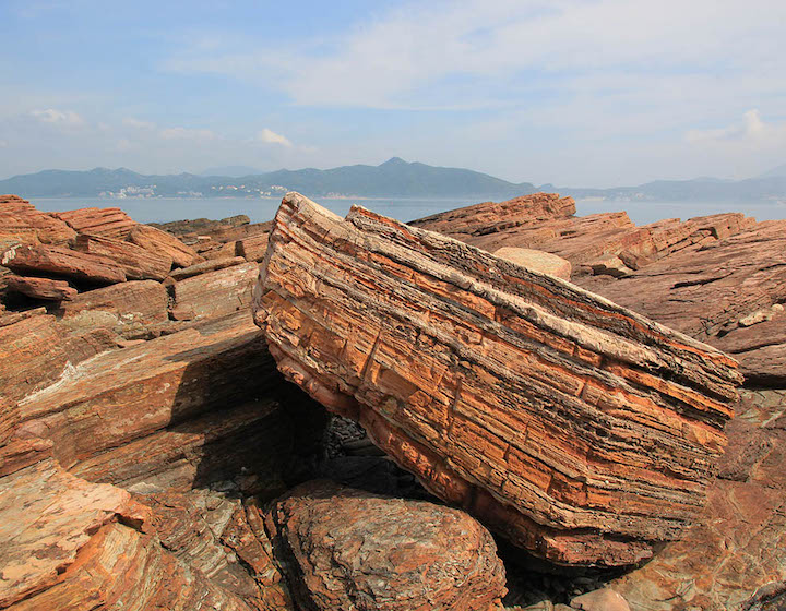
High Island is the most popular section of the UNESCO Global Geopark as it is the most accessible and closest to the Sai Kung pier. Here you can see the enormous hexagonal rock formations that are 140 million years old. Geologists believe these formations were created when lava slowly cooled inside a caldera.
There is also a beautiful sea cave that has been adapted for tourists so that they can get a safe look at the outside of it without damaging its natural beauty as well as a few informational posts about the area. From the reservoir, you can also access section one of the Machlehose trail if you and your family are looking to add a hike to your day trip.
What makes this area great for families with young children is that it is only a 30-minute taxi ride away and there are bathroom facilities located here as well. Taxis regularly wait at the reservoir to take visitors back and there is a sitting area that offers shade on a sunny day while you wait. The area is also not that big which is a great way for young kids to experience the UNESCO Global Geopark without committing to too much.
Sassy Mama Tip: High Island Reservoir can get very busy with tourists so we recommend you take your family out in the morning before or around 10am before the tours arrive.
Read More: How To Visit Po Toi Island With Kids
How To Get To High Island
You can book a half-day tour online with the Volcano Discovery Centre ($250 per person). Be advised that the tour can fill up fast so you may have to plan a week in advance. Additionally, if you want to have more flexibility and want to avoid a structured tour, you can also get a taxi from the Sai Kung Pier. It will take around 30 minutes to get there and will cost around $120 one way.
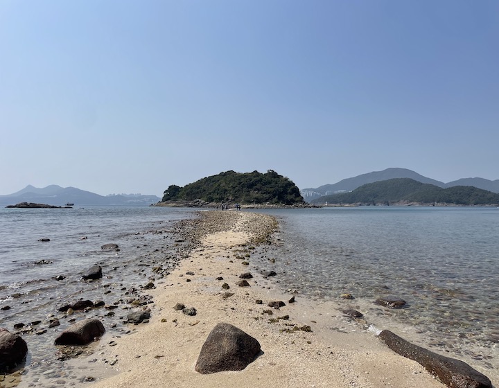
 Sharp Island
Only 2 kilometres from the Sai Kung Pier, you can easily spend a full day on this picturesque island with the family. Sharp Island is a small, long and narrow island shaped by natural wave erosion that is surrounded by gorgeous green spaces and pristine waters. It has a white sand beach, a tombolo and swimming area, with lifeguards on duty, change rooms, showers, toilets and a BBQ area. There is also an additional short hike near the beach and pier side of the island that is also suitable for families.
Read More: Explore Sharp Island With The Family – Transport, Dining And Things To Do
How To Get To Sharp Island
Sharp Island is only accessible by boat but it is very easy to get to. There are many boat companies available on the weekends and on public holidays from the Sai Kung Pier that will offer a round trip to Sharp Island for $30 to $50 per person. What is great about these trips is that you can stay out on the island until the last tour boat leaves. Be sure to ask for the final pick-up time.
Sassy Mama Tip: Spending half a day at the High Island Reservoir and then following up with Sharp Island is an inexpensive and easy adventure for families with kids of any age.
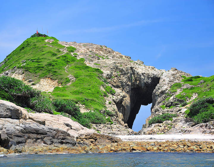
 Ninepin Group
This group of islands is located about 15 kilometres from the Sai Kung Pier. The group contains the South Ninepin Island, North Ninepin Island and East Ninepin Island, along with several small rock islets all of which were created by volcanoes around 160 million years ago. As these islands are farther away and only accessible by boat, this is the type of trip that is best suited for older children.
The islands are out in the open ocean and are susceptible to the weather. Tours and visits to the area should only be attempted in the summer when the weather conditions are favourable and the ocean is calm. Some of the most famous parts of Hong Kong’s UNESCO Global Geopark are found within the Ninepin Islands, such as Jacob’s Ladder Cave, the Stone Arch, Tiger’s Mouth Cave, and Backwash Cave.
Read More: Hong Kong Wetland Park – An Eco Day Trip In Hong Kong’s Wetlands
How To Get To Ninepin Group
As there is so much to see and learn in the Ninepin islands, a tour is a good way to get it all in. The Volcano Discovery Centre offers tours to the Ninepin islands during the summer months, which include a visit to the Leung Shuen Wan Tin Hau Temple (the smallest Tin Hau temple in Hong Kong) and a Hakka village. Prices are $480 per person (for both adults and kids), and you can book online.
Additionally, an easy Google search will give you a tonne of different tour options if you are looking for some variety. The Hong Kong UNESCO Global Geopark lists a few other tour options on its website as well, and you can also look into hiring a private junk if that caters better to your needs.
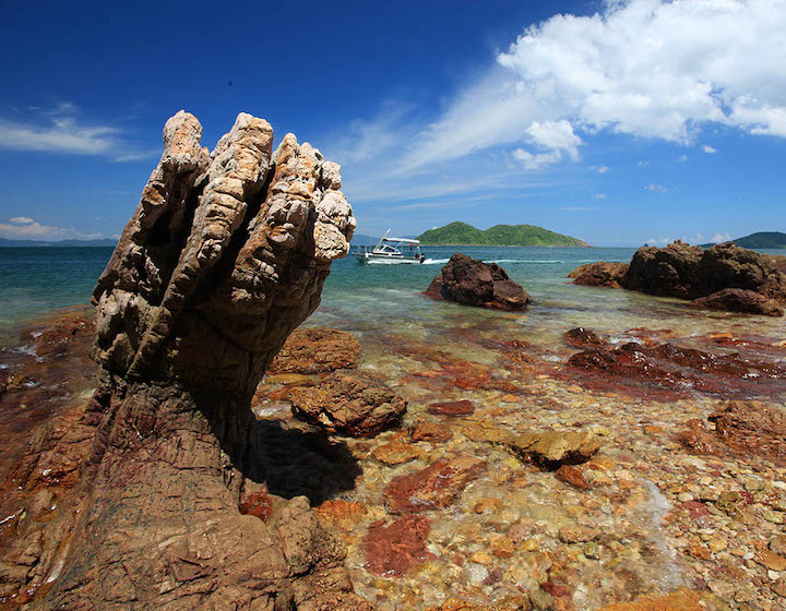
 Ung Kong Chau Group (Bluff Island, Wang Chau and Basalt Island)
These islands were born from a violent shaking of the earth around 146 million years ago causing magma to violently erupt and rise up through the earth melting rock along the way.
Bluff Island has one of the UNESCO Global Geopark’s biggest sea caves and is a popular diving spot. Wang Chau is the smallest of the Ung Kong Chau islands and is home to some impressive sea caves that demonstrate the immense power of how water and wave erosion can affect a landscape. Basalt Island follows in the other two islands’ footsteps with sea stacks, island reefs and wave-cut bays. Basalt Island is also home to a memorial in which a plane travelling from Shanghai to Hong Kong crashed in 1948 killing all 30 people on board.
How To Get To Ung Kong Chau Islands
Getting to the Ung Kong Chau Islands requires you to hire a private boat from the Sai Kung Pier. It is advisable to only visit these islands when the weather conditions are favourable.
Read More: Junk Boats In Hong Kong – Your Guide To Family-Friendly Boat Rentals
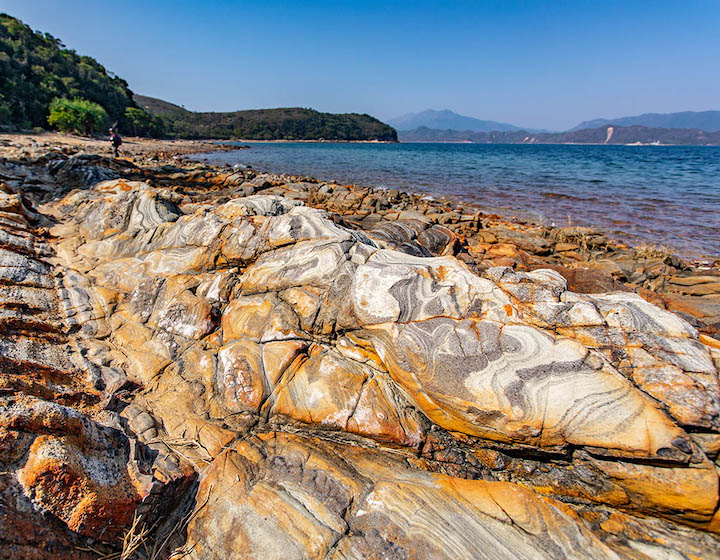
 Lai Chi Chong
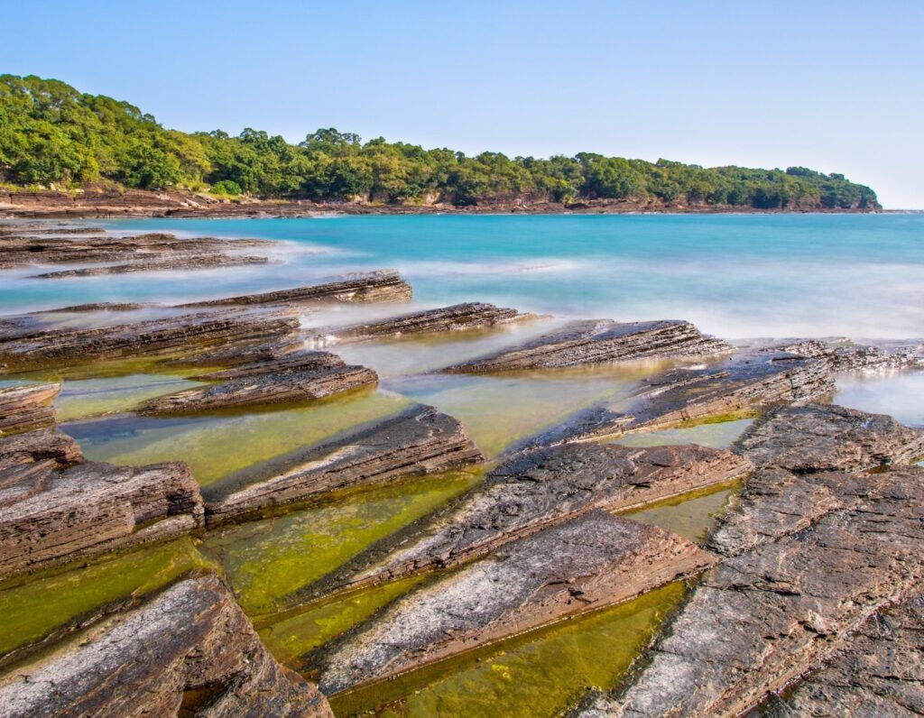
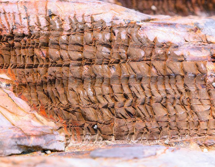
This area is near the north part of Sai Kung Park. The Lai Chi Chong area has some of the most complicated rock formations of the UNESCO Global Geopark. Some sections are older than others while some are younger making for an interesting mash-up of rock formations. A large area of rock is best visible during the low tide but even during high tide, these distinct rocks are still visible.
How To Get To Lai Chi Chong
You can get there from Sai Kung by taking green minibus 7 from the Sai Kung Market and getting off at Pak Sha O. From there you will need to get on the path and walk for about 3.5 kilometres to reach Lai Chi Chong (6 kilometres round trip). If you are coming from the New Territories near Shatin, there is a ferry that goes directly from Ma Liu Shui to Lai Chi Chong.
 Double Haven (Yan Chau Tong)
This island sits above the Plover Cove Country Park and is one of the best places the New Territories has to offer. The island, which is also a designated marine park, came into existence around 180 million years ago with volcanic eruptions destroying the original rock. After the eruptions stopped, the years of erosion and rising waters helped to create the stratum that exists today. Double Haven is absolutely idyllic; the waters surrounding the island are crystal clear and the weather and seas are often favourable all year round due to the island being surrounded and shielded by other outlying areas.
Read More: Picnics In Hong Kong – The Best Picnic Spots For The Family
How To Get To Double Haven
You can take the ferry from Ma Liu Shui to Lai Chi Wo, which will allow you to view Double Haven from the boat. Additionally, the Hong Kong UNESCO Global Geopark has a package tour that also includes Tolo Channel (Wong Chuk Kok) and Port Island-Bluff Head areas.
If you and your family want to turn this into a hiking adventure, you can take the green minibus 20C at the minibus terminus at Tai Po Market MTR Station and get off at the Wu Kau Tang. You can also take 275R at the Tai Po Market MTR station and get off at Bride’s Pool Bus Station and walk to Wu Kau Tang. Both hiking routes overlook Double Haven but will take approximately 4 hours to do a round-trip. Additionally, if you live near Fanling, the 56K runs between the Fanling MTR and can drop you off at Luk Keng in which you can hike toward Fung Hang for a similar view. This round-trip hike will take around 5 hours.
 Wong Chuk Kok Tsui and Port Island
Wong Chuk Kok Tsui holds the title of the oldest rock formation in Hong Kong, around 400 million years old! This formation, having been influenced by years of geological movement, looks almost vertical making for a pretty jaw-dropping spectacle. The most popular and remarkable geological feature here is what has been dubbed the Devil’s Fist. The Devil’s Fist is a unique piece of strata that has been cut away by the waves to resemble a large fist. Please do not climb the Devil’s Fist. In order to protect the feature, tourists are encouraged not to touch or climb on the feature for fear of it being destroyed.
Port Island is the entrance to the Tolo Harbour in Tai Po and it is remarkable due to its bright rust-coloured rocks and sediment. Port Island is just off to the east of Wong Chuk Kok and is the least accessible of the areas in the New Territories as you can only view it by hiring a private boat. However, if you book a private boat you can get them to take you to Wong Chuk Tsui and then up to Double Haven making for a full and fun day.
Read More: Hiking Hong Kong With Kids – The Best Hikes For Families
How To Get To Wong Chuk Kok Tsui And Port Island
While Wong Chuk Kok is not an island and is technically accessible by land, the hike to get there is extensive and extremely challenging. It takes around 7 to 14 hours (yikes!), so it is not a recommended route for families. Your options are to take the ferry offered to Lai Chi Wo and view it from the boat, book a private junk, or the Hong Kong UNESCO Global Geopark site has some package tours that include this area (Tolo Channel) as well as the other geopark areas in the New Territories on its website.
 Tung Ping Chau
While this area may hold the youngest sedimentary rocks in Hong Kong it does not make them any less impressive. The 55 million-year-old sponge cake-like formations envelop this crescent-shaped island and it is a popular spot for visitors. The island is home to the Ping Chau Country Trail is about 6 kilometres in length and follows the entire island coast. The hike is generally flat and could be attempted by families with older children. There are general amenities and interpretation signs and some very cool abandoned villages to explore.
Read More: Stroller-Friendly Hikes Hong Kong – Easy Hiking Trails And Accessible Walks
How To Get To Tung Ping Chau
Take the ferry from Ma Liu Shui to Tung Ping Chau, book a private boat, or explore the tour options at the Hong Kong UNESCO Global Geopark site.
 Ma Shi Chau
The sedimentary rocks at Ma Shi Chau are the third oldest in Hong Kong at 280 million years old. Also located here is the short Ma Shi Chau nature trail that is roughly a 3-kilometre easy hike. Along it you can find 16 different attractions with information posts that point out all the great features in the area and, if you’re lucky, you may even find some marine fossils left behind in some of the rocks. Ma Shi Chau also has a tombolo, a natural sand levee, which you must cross in order to access the island.
The Tai Po Geoheritage Centre is located nearby in Sam Mun Tsai and is another great indoor facility for kids to learn about the area. As Mai Shi Chau is relatively accessible it is a great choice for families of all ages.
Read More: Things To Do In Hong Kong With Kids And Families
How To Get To Ma Shi Chau
From Central take the MTR to Tai Po Market station. You will need to get off at Mong Kok to get on the Kwun Tong Line and then from there get off at Kowloon Tong to get on the East Rail line to Tai Po Market station. You could also take bus 607 from the Statue Square stop in Central to the Tai Po Market MTR station. Once at the Tai Po Market station, take bus 74K or minibus 20K to Sam Mun Tsai village then walk across the hillock in Yim Tin Tsai and reach Ma Shi Chau via the tombolo (approximately 40-minute walk).
Sassy Mama Tip: Tung Ping Chau and Ma Shi Chau are the most accessible and family-friendly of all the areas in the New Territories and could easily make for a fun day with the kids. However, if you are looking to get an overall picture of everything within the New Territories geopark, join a package tour from the Hong Kong UNESCO Global Geopark which are hassle-free and offer great information on the areas by trained guides.
Read More: Best Beaches In Hong Kong To Visit With The Family
Editor’s Note: “A Complete Guide To Hong Kong’s UNESCO Global Geopark” was most recently updated in July 2023 by Najuka Redkar.